After leaving Cahokia, we followed the i70 through Illinois and
Indiana, heading for our next stop in Columbus Ohio. The difference in each state became apparent as we travelled through Indiana, where
the road surface was noticeably worse than our previous route through
Illinois and later when we passed through Ohio the roads improved again.
Another difference was the kind and number of advertisement hoardings
alongside the highway. They changed from hardly any, to being bombarded with
adverts for eating places and fireworks.
We lived on six inch Subway subs whilst on the road, because there were everywhere. They offer the least oversizing fast food and you can decide on the exact filling. TS and family on a visit to us some years ago went into a local Subway and discovered that the then British version was disappointingly different, but over the last few years, apart from the slightly smaller portions of filling put into the sub in the UK, they seem to have got very close to their US counterparts.
 However even the USA Subway sub is
nothing like the real thing you will get if you go to a genuine sub
emporium, where the bread is compressed to a thin shell with a filling
so big there is no room for the bread. Yum! - but they are oversizing food.
However even the USA Subway sub is
nothing like the real thing you will get if you go to a genuine sub
emporium, where the bread is compressed to a thin shell with a filling
so big there is no room for the bread. Yum! - but they are oversizing food.
Our lunch stop that day was in Effingham Illinois. Effingham was founded in 1814 and given the name Broughton but was renamed in 1859. Apart from being the Effingham county capital, it has two claims to fame. First it is sited at the meeting of two major interstate highways, the i70 and the i57 and second it claims to have the tallest free standing cross in the USA. So, not a big tourist attraction, but a lot of people must pass through on their way elsewhere and there are lots of hotels and food outlets.
After lunch, we drove on into Indiana and crossed over the Wabash River just inside the border.
 We
skirted Terre Haute, heading along the i70 for 76 miles to bypass
Indianapolis and on to Richmond and after roughly another 70 miles, over
the state border and then into Ohio. Terre Haute is a reminder of the French influence accross that area, which was part of New France, which once stretched all the way from Northern Canada down to New orleans. The name is derived from the French for 'high ground'.
We
skirted Terre Haute, heading along the i70 for 76 miles to bypass
Indianapolis and on to Richmond and after roughly another 70 miles, over
the state border and then into Ohio. Terre Haute is a reminder of the French influence accross that area, which was part of New France, which once stretched all the way from Northern Canada down to New orleans. The name is derived from the French for 'high ground'.
Indianapolis is the state captital and became so in 1820. It was purpose built and was placed as centrally as posible in Indiana by the planners. The original state capital was Croydon, on the southern border of Indiana. Indanapolis is famous for the Indy 500 race, one of the worlds most prestigious motor races, that traditionally takes place on Memorial Day. The five hundred refers to the length of the race, which is five hundred miles and requires a gruelling two hundred laps around the Indiapolis Motor Speedway.
In Ohio, we continued along the i70 past Dayton and Springfield.
 Springfield is one of the 38 different cities, towns and townships with
that name found in the USA. The cartoon characters the Simpsons live in
a town called Springfield, a name chosen for its anonymity, so that they
cannot be accused of their satire pointing a finger at any particular
place. So, no three eyed radioactive fish in any rivers near
Springfield Ohio.
Springfield is one of the 38 different cities, towns and townships with
that name found in the USA. The cartoon characters the Simpsons live in
a town called Springfield, a name chosen for its anonymity, so that they
cannot be accused of their satire pointing a finger at any particular
place. So, no three eyed radioactive fish in any rivers near
Springfield Ohio.
As we went further East, the land started to change and it became more hilly and the roads started to meander a bit, unlike Western states, where the roads tend to be perfectly straight.

Apart from passing by London, Springfield was the last major town we passed before entering Columbus. Well actually London was not so big, just a dot on the map. There are a lot of Londons in the USA too.
Our journey to Washington took us all over the globe if you went just by the place names, we went past. We passed Bethlehem, Bristol, Cambridge, London, Rome, Carthage, Alexandria and a whole lot of other familiar sounding places, but never left the i70, eventually arriving at Columbus.
Like Effingham, Columbus is on a crossroads but unlike Effingham, it is a lot larger. Population wise, it is about sixty four times larger. Named for the explorer Christopher Columbus, the city was founded in 1812, a fateful year. Britain was already at war with the French when the American settlers, decided to get out from under and picking an ideal time to rebel and eventually won their war. Also in 1812 Napoleon lost a major battle at Moscow.
We found nothing very notable about the part of Columbus where our hotel was, it seemed very run down. We arrived around 7:30 local time, having gained an hour when crossing the state line and went to look for somewhere to eat, but everywhere was closed for the night! We tried several places and eventually got a take out from a Papa Johns.

Apart from searching the local rather sleazy area near our hotel, we did not see a lot of the place, so my assessment of the city is not typical and I am sure there are many nice areas with splendid civic amenities in other parts of Columbus. We took our meal back to our hotel and ate in our room, then left first thing the next day.
Columbus is almost dead center of the state of Ohio,along the i70, and so the last leg of our outward journey took us across the eastern half of Ohio, past Cambridge, over the Ohio River and on into the little northern spur of West Virginia.

I can only assume that many American tourists that arrive in Britain do not visit much else of their own country, because it is very commom to hear them saying how green and wonderful england is. Most of the places around that part of West Virginia and nearby states are just that.
This part of West Virginia is very narrow and so we were only in West Virginia for a few miles and as we went past the town of Wheeling we were in Pennsylvania.

The geography of these eastern state borders becomes quite complicated as small strips and spurs of one state project into or between others and by driving only a few miles, you can often travel in three states within thirty minutes.
At Washington PA not DC, a little south of Pittsburgh, we left the i70 and took the i79 south down towards West Virginia and then in that state we turned off onto the i68.
 This area is close to the Appalachian Mountains and the country became very hilly and very green with forested hills interspersed with fewer and fewer farms and houses.
Shortly after Morgantown, we crossed the state line into Maryland.
This area is close to the Appalachian Mountains and the country became very hilly and very green with forested hills interspersed with fewer and fewer farms and houses.
Shortly after Morgantown, we crossed the state line into Maryland.
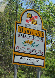 In Britain, the name Mary is pronounced Mare-ee, maybe otheres pronounce it differently, so most Brits would call Maryland Mare -ee land, including news readers on TV, who should know better, but like Marylebone in London, England is not pronounced Mary le bone, although it once was. Maryland is not pronounced that way either and any tourists foolish enough, (heaven forbid) who should attempt to pronounce it as it is spelled, will be ridiculed by the locals. Much the same way that we in England may find amusement in people pronouncing the perfectly ordinary English names of Gloucester, Warwick, Berkeley or Cholmondeley other than as Gloster, War-ick, Bark-lee or Chum-lee.
The road has to cross some highish hills and we got some great views of the beginning of the Appalachians. This is the area is not too far from the Blue Ridge Mountains of Virginia and the Laurel and Hardy song kept running through my head as we drove along. If you don't know it, check it out on You Tube. Follow the link
At Hagerstown, we picked up the i70 again and then at Frederick the i270 which heads directly to Washington DC. We were staying at Crystal City so we crossed the Potomac River into Virginia.

We continued to head down past the Arlington Cemetery, the Pentagon and on to our hotel.
We lived on six inch Subway subs whilst on the road, because there were everywhere. They offer the least oversizing fast food and you can decide on the exact filling. TS and family on a visit to us some years ago went into a local Subway and discovered that the then British version was disappointingly different, but over the last few years, apart from the slightly smaller portions of filling put into the sub in the UK, they seem to have got very close to their US counterparts.
Our lunch stop that day was in Effingham Illinois. Effingham was founded in 1814 and given the name Broughton but was renamed in 1859. Apart from being the Effingham county capital, it has two claims to fame. First it is sited at the meeting of two major interstate highways, the i70 and the i57 and second it claims to have the tallest free standing cross in the USA. So, not a big tourist attraction, but a lot of people must pass through on their way elsewhere and there are lots of hotels and food outlets.
 |
| The cross at Effingham - it is big. |
After lunch, we drove on into Indiana and crossed over the Wabash River just inside the border.

Indianapolis is the state captital and became so in 1820. It was purpose built and was placed as centrally as posible in Indiana by the planners. The original state capital was Croydon, on the southern border of Indiana. Indanapolis is famous for the Indy 500 race, one of the worlds most prestigious motor races, that traditionally takes place on Memorial Day. The five hundred refers to the length of the race, which is five hundred miles and requires a gruelling two hundred laps around the Indiapolis Motor Speedway.
In Ohio, we continued along the i70 past Dayton and Springfield.

As we went further East, the land started to change and it became more hilly and the roads started to meander a bit, unlike Western states, where the roads tend to be perfectly straight.

Apart from passing by London, Springfield was the last major town we passed before entering Columbus. Well actually London was not so big, just a dot on the map. There are a lot of Londons in the USA too.
Our journey to Washington took us all over the globe if you went just by the place names, we went past. We passed Bethlehem, Bristol, Cambridge, London, Rome, Carthage, Alexandria and a whole lot of other familiar sounding places, but never left the i70, eventually arriving at Columbus.
Like Effingham, Columbus is on a crossroads but unlike Effingham, it is a lot larger. Population wise, it is about sixty four times larger. Named for the explorer Christopher Columbus, the city was founded in 1812, a fateful year. Britain was already at war with the French when the American settlers, decided to get out from under and picking an ideal time to rebel and eventually won their war. Also in 1812 Napoleon lost a major battle at Moscow.
We found nothing very notable about the part of Columbus where our hotel was, it seemed very run down. We arrived around 7:30 local time, having gained an hour when crossing the state line and went to look for somewhere to eat, but everywhere was closed for the night! We tried several places and eventually got a take out from a Papa Johns.

Apart from searching the local rather sleazy area near our hotel, we did not see a lot of the place, so my assessment of the city is not typical and I am sure there are many nice areas with splendid civic amenities in other parts of Columbus. We took our meal back to our hotel and ate in our room, then left first thing the next day.
Columbus is almost dead center of the state of Ohio,along the i70, and so the last leg of our outward journey took us across the eastern half of Ohio, past Cambridge, over the Ohio River and on into the little northern spur of West Virginia.

 |
| West Virginia is very beautiful and scattered with farms and woodland |
This part of West Virginia is very narrow and so we were only in West Virginia for a few miles and as we went past the town of Wheeling we were in Pennsylvania.

The geography of these eastern state borders becomes quite complicated as small strips and spurs of one state project into or between others and by driving only a few miles, you can often travel in three states within thirty minutes.
Although we did not stop there, Pittsburgh is an interesting
city, it is on the junction of the Allegheny River and the Monongahela River which
join together to form the Ohio River. Pittsburgh
is famous for Mount Washington which overlooks the city where it sits on the
Golden Triangle between the junctions of the three rivers. This is declared one
of the best views in the USA. Mount
Washington is reached by a very early cog railway that is designed to climb
such a steep incline, that the engines are built on an
angle to keep the boiler level.
 |
| This photograph was taken by my brother in law when he was there some years ago. |
At Washington PA not DC, a little south of Pittsburgh, we left the i70 and took the i79 south down towards West Virginia and then in that state we turned off onto the i68.


The road has to cross some highish hills and we got some great views of the beginning of the Appalachians. This is the area is not too far from the Blue Ridge Mountains of Virginia and the Laurel and Hardy song kept running through my head as we drove along. If you don't know it, check it out on You Tube. Follow the link
 |
| On the edge of the Appalachian mountains |
 |
| Not as high as the Rockies, this was the highest we got |

 |
| Driving along the Virginian side of the Potomac River with the Washington Monument in sight. Unfortunately it has scaffolding all around it. |
 |
| One of the five sides of the pentagon |


Sounds like a long but very interesting trip. I would love to go to America one day for a road trip. It's a bit of a dream of mine.
ReplyDeleteHow long did this trip take you? It seems like you went a very long way.
ReplyDeleteThree days Kansas to Washington DC, four days in DC and then two days back to Kansas. About 3,000 miles all told.
Delete